Philadelphia operates a combined sewer system across a large share of the city; during wet weather this older portion of the system overflows, discharging storm water and diluted sewage into local waterways. Green City, Clean Waters is the city’s long-term response - a 25-year plan, estimated at roughly $2.4 billion, to reduce the volume of storm water reaching the combined sewers using green infrastructure rather than relying solely on conventional gray expansion. Among its core tools are storm water tree trenches: subsurface stone-and-soil systems that capture street runoff and route it to trees instead of to the sewer.
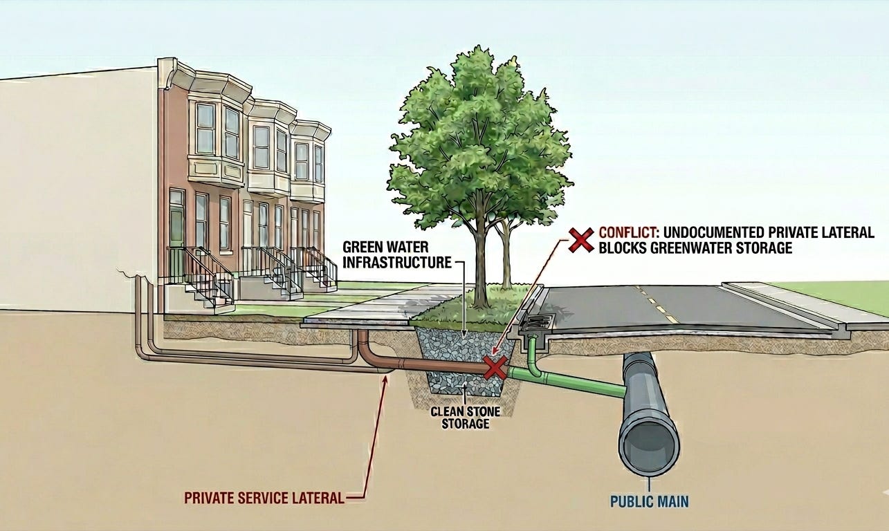
Building these systems on a residential block means installing new drainage inlets and pipe that convey runoff from the street surface into engineered tree boxes. The trouble is, the ground under that street is already crowded with over a century of infrastructure. Much of it was never documented properly.
Cross-section of a residential street showing documented public mains, undocumented private service tie-ins, and a planned green stormwater drainage lateral.
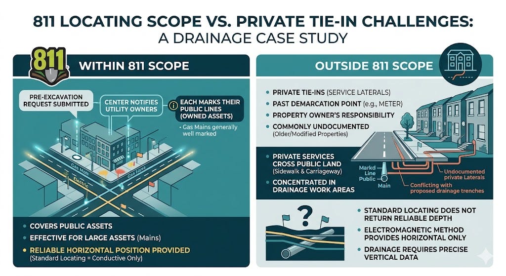
Private tie-ins fall outside one-call locating
Before excavation, crews submit a one-call (811) ticket. This notifies utility owners, and each marks the public lines it owns. This may be effective for large public assets; gas mains in particular are generally well marked. However, the segment running from a main to an individual structure is the property owner’s responsibility.
There are two key reasons why this is particularly material for drainage work. First, these private services are commonly undocumented, most often on older or modified properties. Second, these services do not stay on private land. For example, a line connecting a main in the street to a row house crosses the sidewalk and part of the carriageway—the same ground a drainage trench disturbs. The assets least covered by existing process are therefore concentrated exactly where this work occurs.
Standard locating does not return reliable depth
Electromagnetic locating, the prevailing method for marking conductive lines, is not a reliable source of burial depth. A line located in this manner may sit anywhere from roughly a foot to several feet down. The absence of depth mapping has meaningful repercussions across drainage work.
Comparison of what 811 locating covers versus the private tie-ins and depth data it does not.
Depth governs the design, because drainage runs on grade
Gravity drainage only functions properly when the pipe is laid on a particular slope. Too little slope will lead to standing water, sediment accumulation, and eventual blockage, so the system fails to convey flow and may surcharge the structure it feeds. Because grade is fixed during design, it dictates the required elevation of the pipe at each point along its alignment.
An unmapped utility that crosses the alignment at an incompatible elevation cannot be absorbed in the field, because changing the pipe’s depth changes its grade, and changing the grade requires the engineering team to re-evaluate the design. Standby crew time, extended right-of-way occupancy, and a revision incurs scheduling costs that prior knowledge of the obstruction’s depth would have avoided. The depth of a conflict - not merely its existence - is the operative piece of information.
A better solution
The common requirement across both gaps is a record of the subsurface that (a) includes private assets outside the conventional locating workflow and (b) resolves burial depth, not only horizontal position. SubVysion’s approach is built to that requirement.
The method combines ground-penetrating radar (GPR) with a visual positioning pipeline to construct a three-dimensional model of buried infrastructure beneath a street, with the aim of capturing private service tie-ins alongside public assets. Because the output is 3D geometry rather than a surface mark, it is designed to provide burial depth. The model is then presented to crews as an augmented-reality (AR) overlay registered to the site, rendering line position and depth in place over the ground.